.png)


Stormwater
Stormwater is runoff generated when rain (or the occasional snowmelt) flows over the ground.
Impervious surfaces like driveways, sidewalks, roofs, streets and parking lots prevent rainfall from naturally soaking into the ground.
With roughly 50 inches of rain each year, the City proactively manages runoff from rain events through drainage networks that convey the stormwater into streams, creeks and ponds.
To get a better understanding of what the Stormwater Department oversees and manages, please read the Dunwoody Stormwater Extent of Service document.
Compliance with State Regulations
Among its other responsibilities, the Georgia Environmental Protection Division (EPD) Watershed Protection Branch (WPB) oversees the permitting of municipally-operated stormwater systems that discharge to State Waters. The City of Dunwoody is permitted under the EPD’s General NPDES Permit for Phase II MS4’s. As part of the permit requirements, the City has a Stormwater Management Program (SWMP) that details all activities performed by the City annually to remain compliant under the permit.
One requirement of the permit is to develop an Impaired Waters Plan (IWP) that addresses any streams classified as “impaired” within the municipal boundaries of the permittee. A stream is considered impaired and is put on the 303(d) list when appropriate sampling data shows that a pollutant of concern is consistently above the allowable levels set by the State.
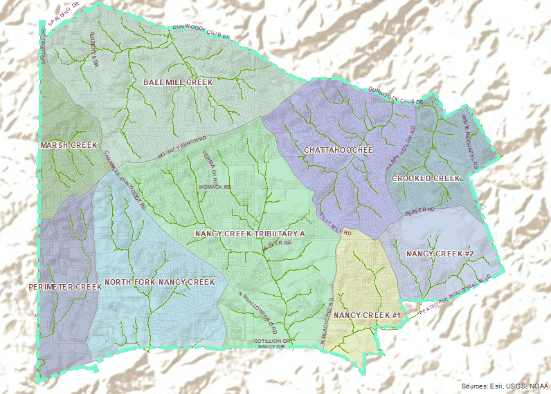
The 2018 list of 303(d) streams was approved by the EPA on June 14, 2019. The list indicates two streams within the City of Dunwoody are impaired: Marsh Creek and Nancy Creek. Both streams are monitored by the City for the pollutant causing the impairment. Although the 2018 list removed Ball Mill Creek, the City is continuing to monitor the segment located in Dunwoody until the end of 2019.
Improving Water Quality
As stormwater flows over the ground, it picks up and carries pollutants (like oil, lawn fertilizers and litter) to streams, creeks and ponds.
While the City works hard to keep pollutants out of local streams, the public can make all the difference when it comes to supporting the health of water resources within the community.
How you can help:
• Don’t Dump Anything Down Storm Drains (and report suspected polluting activities to the City here)
• Don’t Pour Fats, Oils or Grease Down the Drain
• Try Recycling and Throw Litter in its Place